The archaeological area is situated on the "Taccu" of Osini, a striking natural rock with steep limestone walls. It enjoys an exceptional visual dominance over Ogliastra and Barbagia.
The ensemble, of particular charm, includes a complex nuraghe with an adjacent village, a cave with two entrances, two giant's tombs and two single-tower nuraghes.
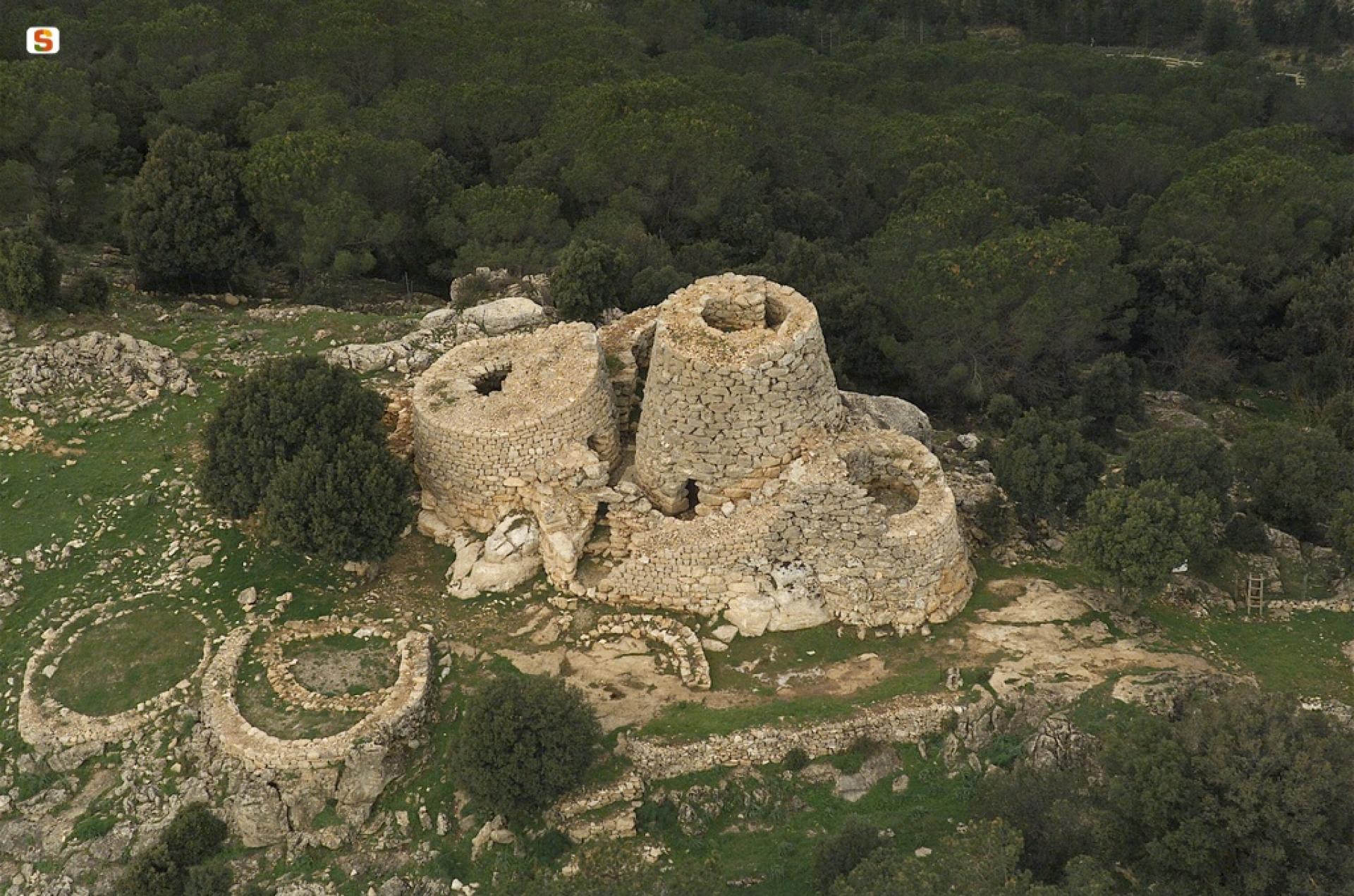
The nuraghe - built on the rock floor incorporating its asperities - is formed by a keep and three towers N-E, S and O. The towers are connected by a bastion, according to a lateral addition scheme. In the connecting curtain of the S and O towers, the entrance to the monument opens, leading into a passage with a niche on the d.. wall.
The passage leads into a narrow curvilinear courtyard-corridor, with a paved floor, overlooking the entrances of the four towers.
The keep - located in a higher position - is made with regular rows of blocks. The architraved entrance, facing S-E (width m 0.95-0.51; height m 1.80), leads into a flared passage (width m 0.95-1.25; length m 2.70; height m 1.80-2.80) with an angular roof of increasing height towards the chamber.
To the s. opens the stairwell - preceded by a small landing (width m 0.95; height m 2.25) - which with 28 steps led to the upper floors.
The ground floor chamber, sub-circular (diameter m 4-3; height m 5.50), preserves intact the ogive roof and the pebble paving.
The upper chamber has an oval plan (diameter m 2.40-1.80; height m 1.55) with a stone slab floor. Two small closets open at the floor level.
The N-E tower (diameter m 7; height m 6), incorporated into the bastion, leans against the keep. The structure encloses a chamber - with a trapezoidal entrance (height m 2.90) facing S and raised about m 2.50 above the corridor floor - and an underlying "tholos" compartment, accessible from the floor of the upper chamber by removing the end stone of the vault; it was perhaps a warehouse.
The upper environment has a paved floor with a hearth and a concavity near the entrance.
The O tower (diameter m 8; height m 6.50) has the entrance facing S-E which leads into a flared passage with a niche to d.. The chamber (diameter m 4.60; height m 3.00) preserves six slightly raised loopholes next to which stone bases of difficult interpretation were found.
The S tower (diameter m 7; height m 3.30) has the entrance facing N-E (width m 0.80-0.63; height m 2) which leads into a straight passage. It leads into the inner chamber (diameter m 3.80; height 3.50) equipped with seven flared loopholes (width m 0.70-0.40; height m 1.60-1).
Of the settlement that extends around the nuraghe, eight compartments pertaining to blocks with centripetal development have been identified.
The huts, circular (diameter m 8.50-7), built with irregular rows of medium-small stones and abundant clay, have wall partitions and pebble floors.
The nuraghe and village complex was in use from the Early Bronze Age to the Final Bronze Age.
In this age, the cave below the archaeological area, which has two entrances on the Gairo Taquisara and Osini slopes, was probably used as a warehouse for foodstuffs.
In the valley floor there is a giant's tomb of the row type with a curved stele, now buried. Another, very damaged, on the E slope of the relief, is of the row type of blocks arranged in isodomic technique.
The Sanu and Orruttu nuraghes, located in the Troculu plain, a short distance from each other, are single-tower.
Near the Orruttu nuraghe there is a hut with a circular compartment and an adjacent rectangular atrium.